Sri Lanka, is a small island in the Indian ocean of 65,000 square kilometers. Despite being also a small island has a wide range of geographic features and is rich in natural beauty. Large area of the country is covered in tropical forests, with hundreds of rivers flowing through them, often cascading in awesome waterfalls. Thousands of living creatures lives in this island and also there are the vivid bird sanctuaries which are belongs to both endemic and visiting birds.
Singharaja Rain Forest
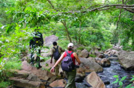
Sinharaja Forest Reserve is a national park and a biodiversity hotspot in Sri Lanka. It is of international significance and has been designated a Biosphere Reserve and World Heritage Site by UNESCO. The hilly virgin rainforest, part of the Sri Lanka lowland rain forests Ecoregion was saved from the worst of commercial logging by its inaccessibility and was designated a World Biosphere Reserve in 1978 and a World Heritage Site in 1988. The reserve’s name translates as the Lion Kingdom.
The reserve is only 21 km (13 mi) from east to west, and a maximum of 7 km (4.3 mi) from north to south, but it is a treasure trove of endemic species, including trees, insects, amphibians, reptiles, birds, and mammals. Because of the dense vegetation, wildlife is not as easily seen as at dry-zone national parks such as Yala. There are about 3 elephants and the 15 or so leopards are rarely seen. The most common larger mammal is the endemic purple-faced langur.
Horton Plains
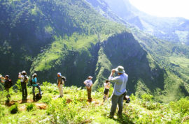
Horton Plains is a beautiful, silent, strange world with some excellent hikes in the shadows of Sri Lanka’s second and third highest mountains, Kirigalpotta(2395m) and Totapola(2359m). The ‘plains’ themselves form an undulating plateau over 2000m high, covered by wild grasslands and interspersed with patches of thick forest, rocky outcrops, filigree waterfalls and misty lakes.The plains’ vegetation is grasslands interspersed with montane forest and includes many endemic woody plants. The surprising diversity of the landscape is matched by the wide variety of wildlife. Large herds of Sri Lankan sambar deer feature as typical mammals and the park is also an Important Bird Area with many species not only endemic to Sri Lanka but restricted to the Horton Plains. Forest dieback is one of the major threats to the park and some studies suggest that it is caused by a natural phenomenon.
The plateau comes to a sudden end at World’s End, a stunning escarpment that plunges 880m. Unless you get there early the view from World’s End is often obscured by mist, particularly during the rainy season from April to September. The early morning (between 6am and 10am) is the best time to visit, before the clouds roll in. That’s when you’ll spy toy-town tea plantation villages in the valley below, and an unencumbered view south towards the coast. In the evening and early morning you’ll need long trousers and a sweater, but the plains warm up quickly, so take a hat for sun protection. The weather is clearest January to March.
Knuckles Mountain Range
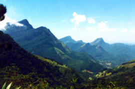
The Knuckles Mountain Range lies in central Sri Lanka, in the Districts of Matale and Kandy. The range takes its name from a series of recumbent folds and peaks in the west of the massif which resembles the knuckles of the clenched fist when viewed from certain locations in the Kandy District. Whilst this name was assigned by early British surveyors, the Sinhalese residents have traditionally referred to the area as Dumbara Kanduvetiya meaning mist-laden mountain range.
The entire area is characterized by is often robed in thick layers of cloud. In addition to its aesthetic value, the range is of great scientific interest. It is a climatic microcosm of the rest of Sri Lanka as the conditions of all the climatic zones in the country are exhibited in the massif. At higher elevations there is a series of isolated cloud forests, harboring a variety of flora and fauna, some of which cannot be found anywhere else in the world. Although the range constitutes approximately 0.03% of the island’s total area it is home to a significantly higher proportion of the country’s biodiversity.
It is a real paradise for those who love to hike or mountain bike , offering numerous mountainous trails that journey across clear rivers, through dense forests, past flowing waterfalls and lush tea plantations, and alongside terraced paddy fields and colorful Kandyan home gardens. The chance to visit traditional small mountain villages in the area gives an interesting insight into the close-knit atmosphere that such a local community fosters and provides a welcome departure from fast-paced modern day life.
Dunhinda Waterfall
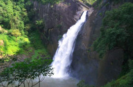
Dunhinda Falls is a waterfall located about 5 kilometres (3.1 mi) from Badulla town in Sri Lanka. The Dunhinda Falls is one of Sri Lanka’s most beautiful waterfalls. The waterfall, which is 64 metres (210 ft) high gets its name from the smoky dew drops spray, (Dun in sinhala means mist or smoke) which surrounds the area at the foot of the waterfall. The water fall is created by the river called Badulu Oya which goes through the Badulla town.
To reach the water fall you have to walk more than 1 kilometre (0.62 mi) along a foot path. Along this foot path you can see another small waterfall called Kuda Dunhinda at a distance. However; walking along this muddy foot path is really worth as the waterfall is so beautiful. Along this foot path there are many native venders selling herbal drinks to refresh and rest yourself. At the end of the path there is a secure stage constructed for viewers to see the waterfall. If you are brave enough you can reach the foot of the waterfall and cross the river and see the most beautiful view of the fall.
Adam’s Peak
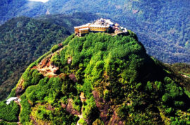
Though not the highest mountain of Sri Lanka, the striking pyramid of Adam’s Peak (7,360 ft) is certainly the most remarkable. Located in a beautiful area of the southern Hill Country, this lofty peak has sparked the imagination for centuries and been a focus for pilgrimage for more than 1000 years.
A depression in the rocky summit resembles a huge footprint, which has been venerated as a sacred sigh from remote antiquity. This was identified by Buddhists as the Buddha’s footprint, by Hindus as that of Shiva, and by Muslims as Adam’s. Later the Portuguese attributed it to St. Thomas the Apostle.
The pilgrimage season begins on poya day in December and runs until Vesak festival in May; January and February are busiest. At other times the temple on the summit is unused, and between May and October the peak is often obscured by clouds. During the pilgrimage season pilgrims and tourists alike make the climb up the countless steps to the top.
As dawn illuminates the holy mountain, the diffuse morning light uncovers the Hill Country rising in the east and the land sloping to the coast to the west. Colombo, 65km away, is easily visible on a clear day. Adam’s Peak saves its most breathtaking moment for just after dawn. The sun casts a perfect shadow of the peak onto the misty clouds down towards the coast. As the sun rises higher this eerie triangular shadow races back towards the peak, eventually disappearing into its base.
